Harris Corp Wins $770 Million Geospatial Data Mapping Contract
Harris Corporation has won $770 million worth contracts to provide geospatial data services for the National Geospatial-Intelligence Agency for up to five years.
Under Foundation GEOINT Content Management (FGCM) contracts, Harris will create high-quality data and products of the Pacific, North America, South America, and Africa regions of the world for use by the U.S. intelligence community and military. FGCM will contribute to and maintain a comprehensive, geospatially accurate map of the world that can be accessed quickly as intelligence, operational, and crisis needs arise.
The company will utilize its One Feature One Time database, which automatically eliminates data redundancy and stores the most current representation of each geospatial feature. This capability ensures data currency and significantly reduces the time required for processing and delivery of products compared with traditional methods.
“Our unique solution provides improved accuracy, reduced production costs and significantly faster turn-around of geospatial products and content,” said Bill Gattle, vice president and general manager, National Programs, Harris Government Communications Systems. “This major win continues our legacy of providing high quality, responsive geospatial products to the intelligence and military communities.”

Harris Corp To Supply 1,500 Falcon III Radios To USAF Special Operations
Harris To Supply Falcon III Radios Worth $88 Million Middle East Nation
Harris' Tactical Manpack Radio Gets NSA Certification
Harris Corp Wins $78 Million Tactical Communication System Order

70 Civilians killed, 360 Injured in Ukrainian Strikes on Russian Economic Targets

Hand to Hand Combat Between Chinese, Philippine Soldiers in South China Sea

2 US troops KILLED, 1 Missing, 4 Injured in Iran Missile Strikes

Russia's Unmanned Systems Group Signs Several International Contracts to Sell its Supercam...

One Month Since U.S., Israeli War Against Iran: Who Is Gaining?
One month after the United States and Israel launched coordinated strikes on Iran on February 28 the conflict has expanded...

Modern Tank Showdown: T-90MS, Leopard 2A7, M1E3 Abrams Compared
Main Battle Tanks (MBTs) have shown their mettle in recent conflicts such as in Ukraine despite being increasingly vulnerable to...
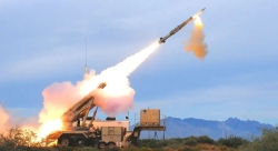
European Nations Prioritizing Europe-made IRIS-T & SAMP-T over American Patriot Air Defense Systems?
European nations looking to procure new air defense systems appear to be giving the much-vaunted American Patriot a miss in...

Russian T-90MS Crew Discuss Future Upgrades
Defense Mirror spoke with the crew members of the Russian T-90MS main battle tank, produced by UralVagonZavod

China's Mass-produced J-35A Aircraft Set to Disrupt Global Stealth Fighter Market
China is aiming to disrupt the global stealth fighter market by mass-producing its fifth-generation J-35A at a pace comparable to...

The Future of Combat: Miniaturized Laser Weapons Set to Replace Bullets and Missiles
Lasers may soon replace bullets, and drones could disable enemy UAVs with beams of light instead of missiles