Navantia to Construct Coastal Hydrographic Vessels for Spanish Navy
BHCs play a vital role in mapping, conducting hydrographic surveys, and providing essential information support to the Spanish Navy.
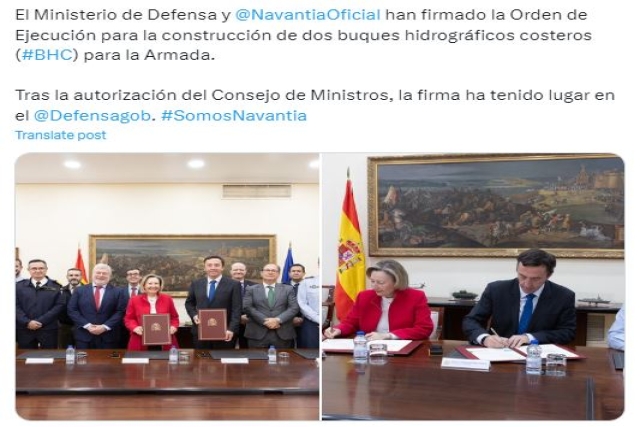
The Spanish Ministry of Defense and Navantia have formalized the Execution Order for the construction of two Coastal Hydrographic Vessels (BHC) for the country’s Navy.
The signing ceremony occurred this Wednesday at the Ministry of Defense, with María Amparo Valcarce, the Secretary of State for Defense, and Ricardo Domínguez, the President of Navantia.
Authorized by the Council of Ministers in August and set to replace the seventies-built hydrographic vessel Antares, the only remaining operational ship of the Castor class, the new BHCs mark a crucial step in the fleet's renewal. Notably, these vessels will contribute to environmental sustainability by operating with biofuels and adhering to the latest emissions regulations.
The primary mission of the BHCs is the preparation and maintenance of the official nautical cartography of the State within Spanish waters and coasts. This responsibility falls under the Navy Hydrographic Institute (IHM), tasked with operating the vessels and publishing and disseminating nautical charts, constituting a vital State mission.
Navantia has submitted a conceptual design to the Ministry of Defense, meeting the necessary requirements for the vessels to fulfill their designated missions. The BHCs will measure 47 meters in length, with a displacement of approximately 900 tons. With a streamlined crew of 30 individuals, facilitated by high automation levels, these vessels will possess a range of 3,000 miles, allowing them to operate in waters up to 200 meters deep for 15 days.
The construction of these vessels will take place at the Navantia shipyard in San Fernando (Cádiz). Over the next four years, the project is expected to generate employment for 700 individuals, including direct, indirect, and economically induced jobs.
The BHCs will be equipped to conduct hydrographic surveys for cartography preparation, offer fleet support with geographical, environmental, and meteorological information, and safeguard underwater archaeological heritage. The vessels will feature hydrographic equipment such as echo sounders, side-scan sonar, and positioning systems to study the water column and seabed. Additionally, autonomous tools like a Remotely Operated Vehicle (ROV), an Unmanned Surface Vehicle (USV), and a hydrographic boat will operate independently to gather and record data and undertake hydrographic and oceanic tasks.

