
U.S. Research Vessel in South China Sea Collecting Data to Support Submarine Warfare: Chinese Media

The U.S. Navy is collecting underwater geographical and hydrological data in the South China Sea since late September using an oceanographic survey ship to support its submarine warfare in the region, Chinese military experts told local media.
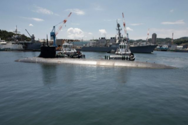
USS Connecticut, the U.S. Navy's nuclear-powered attack Seawolf-class submarine, struck an unidentified underwater object in the South China Sea earlier this month. Another submarine USS San Francisco rammed into an undersea mountain in 2005 while sailing at full speed. It left just about the entire crew injured and took the life of one sailor on board. In order to maintain stealth, the San Francisco had not been operating its active sonar and was traveling too fast to make effective use of its passive sonar. The crew, meanwhile, were using outdated undersea navigation charts that did not indicate the presence of the mountain formation.
"If the (U.S. Navy's) submarine indeed hit terrain, it means the sea map the submarine was using was outdated, and new terrain has formed without the US Navy's knowledge," analysts told the Global Times, noting that the work of oceanographic survey ships could have avoided the accident.
The USNS Mary Sears (T-AGS 65), a Pathfinder-class oceanographic survey ship, entered the South China Sea on September 26 and started extensive surveys, the South China Sea Strategic Situation Probing Initiative (SCSPI), a Beijing-based think tank, reportedly said.
From October 1 to 4, the ship operated in waters south of China's Hainan Island, from October 5 to 9, it approached the coastline of Vietnam, and by Sunday it had arrived in waters near the Nansha Islands.
The American ship is specialized in the detection and surveying of underwater terrain, meteorology and hydrology. The think tank noted that this time, the ship covered a very large area in a short time, which is rare.
While the ship seems to be conducting scientific research, its true mission is to support submarine and anti-submarine warfare, as it can draw underwater maps that can help navigate friendly submarines, or place detection devices to help locate hostile submarines, a Beijing-based military expert told the Global Times on Monday on condition of anonymity.
The U.S. Navy wants to always have updated, accurate maps of the South China Sea so its submarines can safely navigate without using their active sonar devices, making themselves stealthier, or they can find good locations for an ambush, the expert said.
Both the USNS Mary Sears' recent activities and the USS Connecticut's accident showed that the U.S.' intensive submarine activities in the South China Sea, on China's doorstep, are a threat not only to the Chinese Navy if a conflict breaks out, but also to normal, civilian activities in peacetime, the expert said.
Bow of U.S. Navy’s Nuclear Submarine “Seriously” Damaged in South China Sea...

Freedom of Navigation Sailing Root Cause of U.S. Nuke Sub Accident: China...
U.S. Navy's Nuclear Submarine Collides With Underwater Object

Italy to Transfer SAMP/T Air Defense Systems to Ukraine

Russian Forces Destroy Ukrainian IRIS-T System

Toxic Fire at Diehl Metallurgical Plant Threatens Berlin
Hensoldt to Provide Radars, Air Traffic Management Systems for Royal Fleet Auxiliary...

Russia's Growing Influence in Africa: Arms Sales and Military Bases
Russia's expanding influence in Africa, demonstrated by arms sales, military deployments, and diplomatic engagements, reflects a significant geopolitical shift on...

Development Trends in Unmanned Surface Vessels
Unmanned surface vessels (USVs) have caught the attention of the world following their spectacular success in sinking Russian warships in...

Have Iran-Israel Missile Attacks Enabled Mutual Deterrence?
Iran's April 13-14 missile strike against Israel marks a paradigm shift in Tehran's approach to Israel; from previously relying on...

Free Flight to Russian Hypersonic Missiles as America's Own Hypersonics Program Delayed to 2027
As Russian Aerospace Forces pummeled Ukrainian positions in mid-March 2024 with hypersonic missiles, the Pentagon's own hypersonics program faces delays,...

Counter-trade, Undisclosed Deals May be Masking Russia’s Arms Export Numbers
A Stockholm International Peace Research Institute (SPIRI) report last week reported a steep fall in Russias arms exports- pushed to...

China’s “Moderate” 2024 Defense Budget Hides Frenetic Military Build-up
China on Tuesday revealed a draft defense budget draft for 2024 amounting to 1